

xkcd #3122: Bad Map Projection: Interrupted Spheres
Title text:
During the most recent glacial maximum, it’s believed that land bridges extended from the surfaces and connected several of the spheres together.
Transcript:
Transcript will show once it’s been added to explainxkcd.com
Source: https://xkcd.com/3122/
You must log in or register to comment.
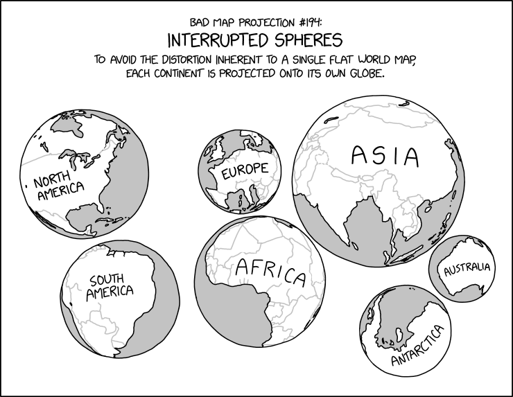
Cartographers might try to tell you the continents on these maps are distorted - but it’s just their projection!
!mapswithoutnz
Aww it’s not a community (yet?)
Well I think you need to add the instance name too
Edit: wait no I didn’t do it right either
!lemmywithoutmapswithoutnz
And without the Arab countries like the UAE
I actually kind of like this as a concept for showing the world!
I like how the globe for Australia keeps the trend of not including New Zealand going.
I mean, NZ would be its own globe because it’s a separate country.
But the Australia globe is potentially missing Tasmania.
Is it its own continent? Because each sphere is a continent.
Doesn’t it have to be if it’s an island? I feel pretty stupid right now lol
Ha, I missed that! 😁
so did the cartographer
There really is an xkcd for everything.
this is actually very close to pseudocylindrical projections (an example is the orange peal like sliced maps, wiki says its called Goode homolosine). they look wierd, are dicontinous, but still largely preserve area and angles.
this one is very similar, except sizes are still wierd, and uses different radii spheres, which makes it both non angle and size preserving.
Cool except Europe is a sub-continent at best, not a continent.
Continents are generally identified by convention rather than any strict criteria.
Honestly at this point you’re just being obnoxious
Oh shit, found the Europeans. lol
My mom’s ass is a sub-continent.
It’s her most appealing feature!
Interestingly, continents are super complex and there seems to be a continent hidden underneath the Mediterranean. A good YouTube video on the subject
Look at you with facts and shit.
You get a gold star buddy!
Why so aggressive? Did someone hurt you?
Where are you from that you think that was aggressive?
Has humor completely died or do you need an excess of emojis to convey tone?
The tone was condescending yes.
The tone was humorous. You took it as condescending.
Communication is a two way street. If what you meant to convey as humorous did not land as such, but instead as condescending, maybe try reflecting why and how you can improve your communication in the future.
So, there’s 4 continents? Abya Yala, Afrasia, Australia and Antarctica
Scratch that, there’s three. Australia is just an island with overgrown ego.
It’s Turtle Islands all the way down, man.
If it were divided by continental tectonic plates, it would be welcome news for Southern Asia and most of the Middle East, but terrible news for New Zealand, Iceland, and the Caribbean.
The real problem is how slowly tectonic news travels.
What do you mean? New Zealand is the big winner in that classification, what with Zealandia being one of the biggest masses of sunken continental crust on Earth.
In terms of continental plates, as I understand it, Zealandia straddles the Pacific and Indo-Australian plates, so if this map were split by major continental plates, New Zealand’s north and south islands would be split.
But I’m not a geologist.
You’re right, at least if you divide continents by being separated by surface water on all sides.
And you’re a fuckin nerd lmao
It’s really weird what yanks some peoples chain. lol


